
"This is a story about communities doing social mappings in target villages of KESEMPATAN Project”
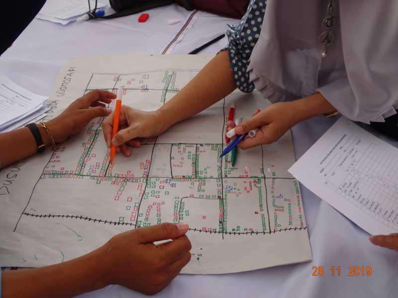
One word to describe this two-day process, salute! It is a perfect word to describe community members from six sub-villages in Wringintelu Village carried out brain-draining activities with strong determination to complete the task, creating Sub-Village Maps.
Yes, the sub-village map is one of the tasks that must be completed in the Social Mapping process. It is aimed to understand the condition of the villages and sub-villages where KESEMPATAN project is carried out and to identify potential beneficiaries.
The two-day event, 27-28 November 2019, took place in the Wringintelu Sub-District Office, Jember and was participated by representatives of Integrated Healthcare Centre (Posyandu) cadres, educators, village councils, village officials, village heads, and community leaders. The organizer had to do extra preparation in terms of finding the right schedule for everyone to fully participate in this two day event.
On Day 1, the task had to be completed included creating village maps and seasonal calendar which were accomplished in a relatively short time. Working in groups made the works easier as participants had diverse information and they quickly defined the division of task in the groups. After presentation and discussion of the result, the next part was the complicated one. The group had to divide themselves into smaller groups according to their respective sub-villages. There were three to five people for each smaller group where they were asked to create sub-village maps.
What is a Sub-Village Map?
The sub-village map is a more detailed picture of the area compared to the village map produced in the preceded session. At this session, participants were asked to describe in more detailed the house locations of their community members. The Groups had to identify locations of all families living in the sub-village, wealth rank of each family and whether there are children in the families who meet the criteria of potential beneficiaries. Once all families in the village listed, participants agreed on families to be prioritized as potential program beneficiaries and surveyed them to validate the data and to get more information on the family condition. Thus, potential program beneficiaries were determined according to certain criteria, not merely by random targeting.
Indeed, creating a sub-village map is a complex process. Could you imagine the tasks that gave the participants headache? If not, the following described the required special skills to complete the task in trying to remember all families and their location as well as to discuss the families' characteristics and to draw them in a village map.
Commitment to completing the task
The social mapping was continued to the second day. It was supposed to finish at 10 AM but it went on until after lunch time. All participants showed their commitment to complete the sub-village maps. There were those who drew the house location in the maps, wrote down each family name, marked the houses with different colour to differentiate their wealth rank or tidied up the maps—everyone basically contributed to create the informative maps. However, even though all the energy and concentration had been used, at 4PM, there were still two groups could not finish the works. After all, the activity had to be continued to the survey session (how to conduct the survey) while these two groups continued to finish their tasks.
Gradually completing the tasks
In this context, drawing did not only involve colourful markers, but also a sense of caring. Gradually, participants had to identify the house locations while remembering the name of the family head, the family condition, to record the number of children in the family, as well as to check whether these children go to school or fall into the vulnerable category. Some participants even missed the snack time as they tried to finish the drawing of the house blocks. It was such a meticulous task with gradual progress. None of the groups were tempted to jump over the process in order to finish the task immediately. If participants did not know a particular family, they would validate it from other sources—such as opened their notebooks, called someone, or discussed with other participants—to ensure the information they wrote is credible. Could you imagine the hassles if there were about 700 households in the sub-village? The number of residents in the sub-village varies, but there are sub-villages that have 700 families.
These sub-village maps are the manifestation of their extraordinary teamwork. It required conscientiousness to ensure the best interest of the child where they wholeheartedly sought the whereabouts of children involving in agricultural work. We might call these children as child labour, however, the participants might have a different perspective. From the results of discussions with the participants, the children work for various reasons—an excuse to not going to school to help their parents, learning process, the habit of doing work at a certain age, and others.
These sub-village maps are the initial guide for local community members, facilitated by the programme team, in analysing the condition of the families and children. The social mapping results provided a lot of insights to design the activities based on the needs of children and their families.
Notes:
*KESEMPATAN Project is a project aiming at preventing children from engaging in works in agriculture. It is being implemented in East Java and West Nusa Tenggara by JARAK with support from Eliminating Child Labour in Tobacco Growing (ECLT) Foundation.
-
-
This article was first published in Indonesiana
Author: Maria Clara Bastiani